“Spend as much time as possible on mountains, in small boats, or otherwise out in the weather; if you never get wet, cold, exhausted or scared, you won’t properly appreciate being dry, warm, rested and safe.” ~ Peter Jay

"I’m an adventuring river rat at heart. Put me on a floating piece of driftwood and I’m happy." ~ Christina Glauner

"There’s folly and foolhardiness on one side and daring and calculation on the other." ~ C.S. Forester's Horatio Hornblower novels

Sunday, May 31, 2009

Dissecting Farm Island

Well, today I paddled up all four channels into the interior of Farm Island. It was a nice afternoon, but a little warm and breezy. Temperature was in the upper 80s and the wind was about 12 mph. I had something to photograph in the first second of my paddle too. A car jumpstarting a boat!
All it takes to jumpstart my boat is some water or coffee if it is in the morning! It's hard to see, but there is a good-looking, bikini-clad gal behind the car too.
The trip ended up covering 6.8 miles.  
Almost immediatley as I began to enter the channels, I came across a bunch of pelicans sitting atop a partially submerged log.
I also came across the remains of a building that I do not recall seeing before. I assume that I have because I am certain I have been down all the channels in the past though.
And then there is the remains of the building I don't forget.
The motorboat and personal watercraft traffic is picking up for the summer. There were numerous vessels zipping back and forth between the boat ramp and the entrance to the channels. The ONE benefit that $4/gallon gas had was that the personal watercraft were fewer in numbers last summer.

Saturday, May 30, 2009

Peoria Flats to East Shore

John and I have completed another section of Lake Oahe. We met at the East Shore boat ramp, loaded my boat and gear onto John's Tracker and headed for Peoria Flats. Until recently, the Peoria Flats has been high and dry. The recently submerged trees reminded us of the movie Deliverance.

We ended up paddling 5.5 miles from Peoria Flats to East Shore. It turned out to be a beautiful day and we wished we had chosen a longer stretch, like Spring Creek to Peoria Flats or around Little Bend.
Launching from Peoria Flats.
Slideshow:

Friday, May 29, 2009

Paddlin' Around Popcorn

Yesterday I wanted to try a paddle all the way to the dam from the causeway. But between me not getting to the causeway until about 6 PM and a popcorn storm blowing through, I chose to just dink around in the river. I didn't even completely miss out on the storm; despite all the clouds being over town not the river, I still got pelted by heavy rain for something like 30 seconds. I did manage a couple of pics of a rainbow and some nice pics of "butter like water", wake boarding term for what I call glass like water. I ended up with just 3 miles.

Wednesday, May 27, 2009

Night Paddle

After work I went for a run and then picked up a pizza at Papa Murphy's for supper. The plan was to eat and then go out for an evening paddle. Problem is I dosed off on my couch for 30 or 45 minutes. The next thing I know it is 8:00 PM. I started gathering up some paddling gear, figuring that I would at least drive down to the causeway before making a decision. Still being a little drowsy, I didn't get down to the causeway until 8:45 PM. I some how managed to convince myself to go out anyway.

I put my beacon on the back of the boat and wore a headlamp on my hat; though I only used the beacon. I ended up paddling downstream from the causeway to the Bad River, looping upstream to the railroad bridge, and returning to the causeway. Distance covered was 3 miles. I always like how tranquil the water is at night. If I didn't go into work at 7 AM, I might have stayed out until it was darker. But I managed some decent pictures.

Monday, May 25, 2009

A full crew!

It wasn't a beautiful afternoon, but it proved acceptable. Chuck, John, and I met at the causeway at 2 PM. We began paddling upstream against the wind and the current. It was tough going. When we stopped paddling, we would lose ground! After about 40 minutes, Chuck turned back so that he could meet up with his daughter. John and I pushed on to a small island. It took us an hour to reach the island and only half an hour to get back. We ended up covering 4.5 miles.

Fighting the wind.


What? The wind stopped once we turned around!

Saturday, May 23, 2009

Skunk Creek

We met at  Jerry Foy's house at 5:30 AM, which was quite fun thanks to the graduation class from 
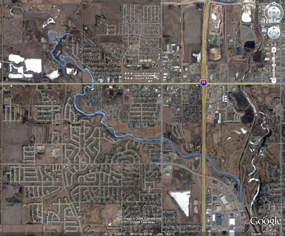
Garretson's high school. By 6 AM we were launching our boats: 7 kayaks and a canoe. We did get rained on a bit, but nothing that a splash jacket, a spray skirt, and a good hat could't withstand. The temperature was in the mid -50s and the wind was not a factor.
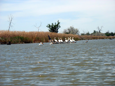
I recall seeing a pair of deer besides the larger group that Jay mentioned on his site. I also think I saw the backside of a coyote running off; though it may have been something else. Sorry, no pics of it. 
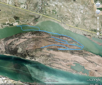
I came up with a total distance of 5.36 miles.
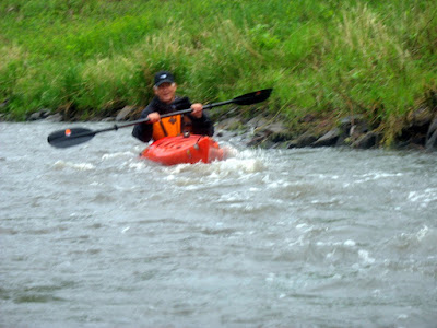
I think everyone enjoyed running the faster water/rapids/ripples. Definitely made good pictures. I'd put names by more of these pictures, but I am horrible with names. If one of the pictures is of you, leave a comment with your name and which picture is of you.
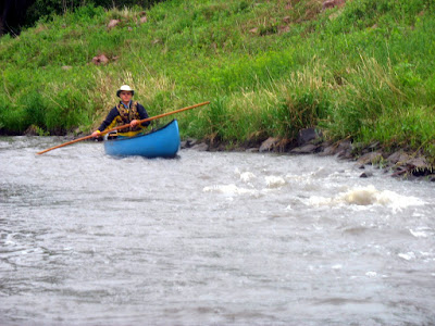
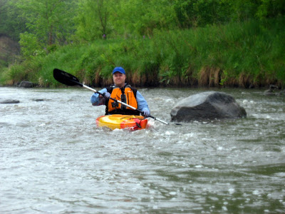
This gentleman was very energetic about running the rapids. He also is greatly helping my sites visibily by taking 3 of my new stickers. Thanks to Jarett and the SDCA blog, I am reminded that this is Corey.

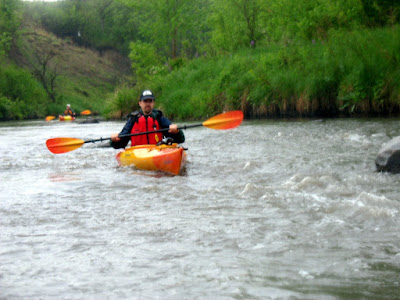
This gentleman was on call during the cruise, but never got a call. He rode with the first gentleman.

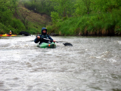
Our fearless trip leader, Jerry Foy. Again, thanks Jerry, for the enjoyable trip.

SDCA President Gene Preston poling his canoe.


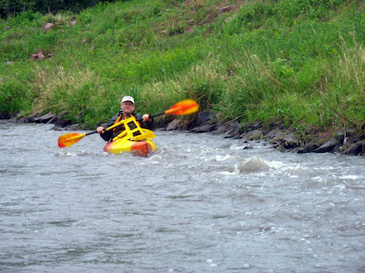
Jay Heath looks like a pro!

This trip is worth repeating in the years to come. The turnout was about right too; many more and the creek would have seemed crowded. 
Also, as I mentioned above, I now have and am giving away stickers bearing the PiratesoftheMissouri.com logo and web address. They are 3" diameter (circular). I didn't get a chance to offer them to everyone on Saturday, because I nearly forgot that I had them. I plan to have them along on every SDCA trip I participate in, so any one interested in one just needs to get out and paddle this summer. Eventually we should bump into each other.


A slideshow of all the pictures I took.

Splitrock Creek and Devil's Gulch

On Friday, I drove down to Garretson to camp at the Splitrock City Park. I did this so that I could join other SDCA members on an early morning Skunk Creek cruise. While I was there I decided to paddle around in Splitrock Creek and Devil's Gulch. Not too much to report. I did about 2.5 miles.

One negative about my night here: The some of the graduating class from the local high school also used the park for a party. Needless to say, my sleep was interrupted.

Monday, May 18, 2009

90 Degree Circumnavigation

It was beautiful today. It hit 90 degrees so I decided to go for a paddle after work. When I arrived at the causeway I wasn't sure what direction I would head until I saw that the water level was up. I quickly decided to circumnavigate La Framboise Island. As I was preparing to launch, a pair of jetskis sped by the boat ramp... I guess I have to start watching out for them again.
I may have seen more wildlife on this La Framboise Island circumnavigation than any other. Started with three turtles sunbathing, a buzzard flew low from the sandbar over to the main island, and finally I saw three or so white tails run into the island. Though I didn't see any other part of the deer. I also failed to capture the buzzard or the deer with my camera. After coming around the island the boat traffic picked up. There were even two boats pulling wakeboarders. It must be summer! The trip ended up being 5.7 miles.

Wednesday, May 13, 2009

An Evening At Farm Island...

Yesterday evening John and I decided to go out for a paddle. Because of the possibility of storms and the wind picking up, we chose to paddle alongside the Pierre side of Farm Island. That way we had some where to come ashore if the weather got bad too soon. We ended up covering 5.7 miles. The wind picked and switched direction on our way back from the tip of Farm Island; we could  also see lightening in the distance, but we only had a few sprinkles fall on us. And we were off the water soon after.
From 2009_05_12
From 2009_05_12
From 2009_05_12
John letting his wife know we are heading back.
From 2009_05_12
Pretty cool looking...

Monday, May 11, 2009

After Work Cruise

After work today I decided to go for a paddle. But I was limited on time. I needed to pickup a pizza at Domino's and get over to my parents' house in time to watch The Big Bang Theory with my mom. Sort of a belated Mother's Day celebration. So I decided to just dink about around the campground and boat ramp at Farm Island (Domino's is on the way back into town). I ended up putting in nearly 3.5 miles and made sure that John could see me... give him a hard time about not paddling :)
From 2009_05_11
Land Ho!

From 2009_05_11
It's hard to see, but there is a fish caught in this contraption.

From 2009_05_11
From 2009_05_11
Poor John's boat :( It isn't wet. But I feel even sadder for Chuck's boats :)

Sunday, May 10, 2009

Unnamed Creek

While Chuck was flying his model planes and John was setting up his RV to spend the week camping at Farm Island (he really needs to rent his house out during the summer), I decided to try to get a little paddling in this evening (late afternoon really). I put in at the boat ramp near the polo fields at Farm Island and paddled around the little islands, up to an unnamed creek, and back to the ramp. It was quite relaxing. I put in an easy 3 miles and was only on the water about an hour. I did get some good pictures of pelicans and a goose too.
From 2009_05_10
From 2009_05_10
From 2009_05_10

Saturday, May 9, 2009

Okobojo Point

I drove up to Okobojo Point, where John was camping, to go paddling this afternoon. This was my first endeavor onto Lake Oahe. Luckily the wind stayed down for the most part. We headed in a westerly direction; this part of the lake is a bend that runs east-west. We paddled about 3 miles to a point where John hid a geocache and then returned to the campground. We covered a total of 5.8 miles. The map below looks like we paddled over land, but I think the aerial photo was taken when the water level was down.

View 09-MAY-09.kmz in a larger map