Friday, December 30, 2011
Thursday, October 27, 2011
Oahe Dam to Ft George
Just a quick update.
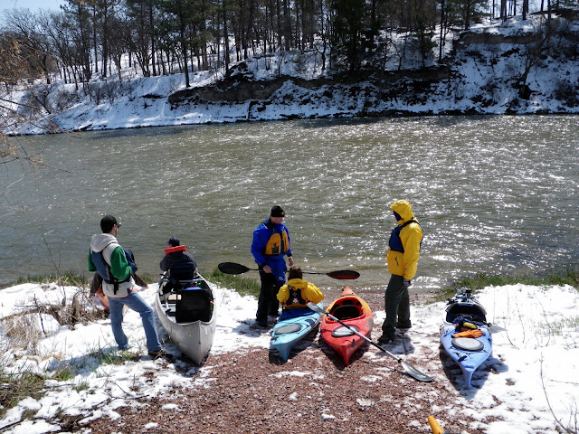
Last Saturday, I met some fellow paddlers at the seldom used boat ramp on the east side of the Oahe Dam. There was Chuck and Dave from Pierre. Diana, from Pickstown, was paddling with Chuck. Matt from Canton and Roger from Brookings.
Saturday morning I dropped my boat off with Chuck and helped him load his boat and mine onto his car. That's right, the Honda Fit carried an 18' tandem and 17' sea kayak simultaneously! I then went out to Oahe Downstream to reserve a campsite for Roger, Matt, and myself for Saturday night.
About 20 till noon, I headed out to Ft George Recreation Area to meet up with Roger and Matt. Dave, Chuck, and Diana would be meeting us at the Oahe Dam east boat ramp. Chuck and Diana also dropped Diana's vehicle off at the American Legion for an earlier take out. I think we began the cruise around 1 PM.
Earlier in the week, the Corps of Engineers found and removed many buffalo skulls, bones from a sand bar near the stilling basin. They missed at least one.

The forecast was for calm winds, but the wind started to pickup as we approached the Pierre city limits. Strangely, it calmed down after Chuck, Diana, and Dave got off the river at the causeway to La Framboise Island.
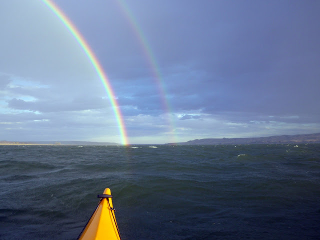
Not too much exciting to report. A small rainstorm passed us by during the cruise and brought with us a stiff tailwind that produced the biggest waves either Roger or Matt had been in. We also had the privilege of seeing a double rainbow.
My GPS had us covering 26.66 miles on the day as we finished with the sunset. After the the long paddle, we chose to have supper at Mad Mary's steakhouse rather than try to cook something at the campsite.
Last Saturday, I met some fellow paddlers at the seldom used boat ramp on the east side of the Oahe Dam. There was Chuck and Dave from Pierre. Diana, from Pickstown, was paddling with Chuck. Matt from Canton and Roger from Brookings.
Saturday morning I dropped my boat off with Chuck and helped him load his boat and mine onto his car. That's right, the Honda Fit carried an 18' tandem and 17' sea kayak simultaneously! I then went out to Oahe Downstream to reserve a campsite for Roger, Matt, and myself for Saturday night.
About 20 till noon, I headed out to Ft George Recreation Area to meet up with Roger and Matt. Dave, Chuck, and Diana would be meeting us at the Oahe Dam east boat ramp. Chuck and Diana also dropped Diana's vehicle off at the American Legion for an earlier take out. I think we began the cruise around 1 PM.
Earlier in the week, the Corps of Engineers found and removed many buffalo skulls, bones from a sand bar near the stilling basin. They missed at least one.

The forecast was for calm winds, but the wind started to pickup as we approached the Pierre city limits. Strangely, it calmed down after Chuck, Diana, and Dave got off the river at the causeway to La Framboise Island.
Not too much exciting to report. A small rainstorm passed us by during the cruise and brought with us a stiff tailwind that produced the biggest waves either Roger or Matt had been in. We also had the privilege of seeing a double rainbow.

My GPS had us covering 26.66 miles on the day as we finished with the sunset. After the the long paddle, we chose to have supper at Mad Mary's steakhouse rather than try to cook something at the campsite.
Monday, October 3, 2011
Return of the La Framboise Island Circumnavigation Cruise
Last Monday, September 26, Chuck and I put in near the American Legion cabin and paddled to the causeway. We then portaged over the causeway and relaunched from the boat ramp. We paddled upstream, around Discovery Island, and then began our downstream excursion.
 We had to stay out in the main channel to keep from being pulled through the breach in the causeway.
 We took a short side trip to check out the Bad River boat ramp.


We continued on and paddled through the chute/channel alongside La Framboise Island. The sun was setting as we came around the end of the island for the final stretch. If memory serves me correctly, we covered 6+ miles on the day.


We continued on and paddled through the chute/channel alongside La Framboise Island. The sun was setting as we came around the end of the island for the final stretch. If memory serves me correctly, we covered 6+ miles on the day.
Friday, September 23, 2011
La Framboise Island
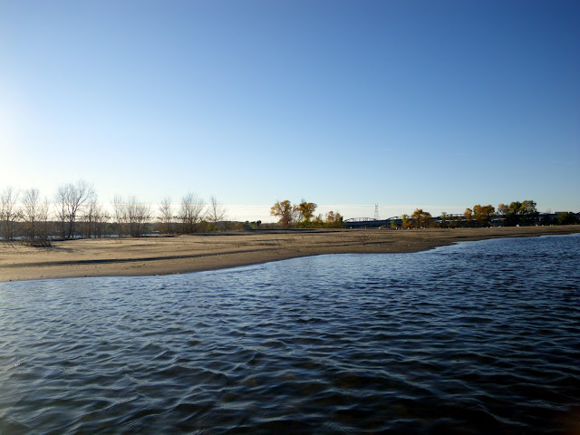
Yesterday I launched from Griffin Park and continued downstream to the end of La Framboise Island. I then proceeded up the channel alongside the island. There was lots of debris on the shore. As I neared the upstream end of the channel, I noticed that much of the reeds on the adjacent sandbar were gone and showed no sign of returning. In fact, it looked like additional sand was deposited. At the upstream end, I pulled the kayak out and walked further up. Time was a limiting factor, so I didn't get too far. I hope to return and try to get further into the island at a later time.


Monday, September 5, 2011
New Boat
Indy and I took my new (to me) boat out for a maiden voyage. It is a tan colored Mad River Explorer 16 canoe with wood gunwales and wood/wicker type seats. I even managed to do the canoehead type carry to haul the boat. I was impressed, with the thwart/yoke on my shoulders, the 70 lbs. canoe was very easy to haul... maybe easier than my 60 lbs. CD Storm GT sea kayak.


Monday, August 29, 2011
Paddling Forgotten Waters
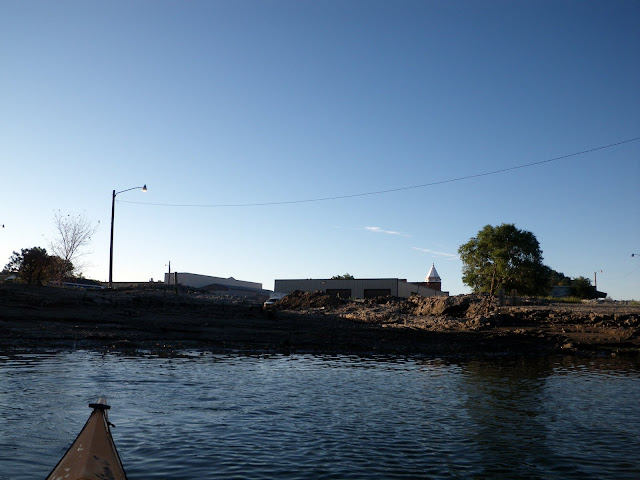
The governor lifted the boating ban on the Missouri River near Pierre today. Obviously, I had to get on the water... water that I have not paddled since May. I parked on a side street near the American Legion cabin and carried my boat through a hole punched through the levee for storm water drainage.
I paddled downstream along the Pierre shoreline to the end of La Framboise Island and then back upstream to the causeway. The only major damage through this area was to the causeway, which was significant (see videos). I ended up covering 6.2 miles.
Wednesday, August 3, 2011
Into Farm Island...
I won't go into great detail, but over the past week I have managed to paddle in and about Farm Island on a few occasions. The fingers/inlets into the island I have always enjoyed exploring are even more interesting when I can travel further up them and jump between them by paddling through tall grasses. I have also paddled through the main campground area a couple of times. Also, near the causeway, there is a small inlet that is now much larger. When exploring it, you now can hear water rushing over the causeway somewhere among the trees and you have to constantly fight the a strong current to keep from being pushed into trees/strainers. I am still far from done exploring the area; hopefully I will have more to share later this week.
View Farm Island August 2, 2011 in a larger map
View Farm Island August 2, 2011 in a larger map
 |
| From 2011-07-30 |
 |
| From 2011-07-30 |
 |
| From 2011-07-30 |
Monday, July 25, 2011
Farm Island
Good news! I nearly had Chuck on the water this evening. I mentioned to him at noon that I was going to paddle Farm Island again and he sounded excited to get out. Sadly, he had something come up at work and could not make it, but I think he will be paddling within a week.
You know it is windy when you come across a wind surfer:
I also explored a little bit of the finger inlets into the island, the campground, and surfed some wind generated waves.
You know it is windy when you come across a wind surfer:
I also explored a little bit of the finger inlets into the island, the campground, and surfed some wind generated waves.
 |
| Paddling OVER a bridge. |
Big Sioux / Skunk Creek / Big Sioux
I was in Sioux Falls over the weekend for the Dakota Irish Fair on Saturday and to do some paddling on Sunday. After waking up, showering, and packing my tent, etc., I met Ryan Snuggerud at Perkins on Cliff Avenue for breakfast and to discuss where to paddle. We settled on making the run from Lien Park to the Big Sioux Recreation Area. During the paddle, we easily maintained a speed of 5.5 - 6 mph. It took roughly 2 hours to cover the 11.2 miles. There were plenty of downed trees in the river, but none were too difficult to get around.
View Lien Park to BSR Rec. Area in a larger map
At 1 PM, I met a group of paddlers led by Dave and Mary Fink (and included Roger Debates). We put in on Skunk Creek at Legacy Park and took out of the Big Sioux River at 26th St. Another easy paddle. We passed a few paddlers and a group of folks tubing down the river. There were a few ripples, but much less debris than in the morning. The only incident that I know of is that Dave Fink managed to take a swim while we were still on Skunk Creek. I am not sure if it was in one of the ripples or not though. It wasn't long before his boat was emptied of water and we were headed downstream again. Roger and I covered about 9.6 miles, including a couple of short jaunts back upstream in about 2 hours.
View Legacy Park to 26th St. in a larger map
View Lien Park to BSR Rec. Area in a larger map
 |
| From 2011-07-24 |
View Legacy Park to 26th St. in a larger map
Friday, July 22, 2011
Farm Island
Today, the governor opened the river up from the Farm Island causeway downstream. Obviously, I had to go check out what the area was like with high water. I paddled from the boat ramp down to the fingers/inlets into the interior of the island. I went up one of the inlets, noting the Lewis and Clark monument and old building. I then paddled back to the boat ramp and into the campground area. I ended the paddle in the boat ramp parking lot! Covered 4.9 miles.
Sunday, June 26, 2011
Rockin' Split Rock
I've been seeing many Facebook posts about paddlers gaining glory on Split Rock Creek and could not sit idly by. So, I took this weekend to get out of Pierre and do some paddling and camping near Sioux Falls. A college friend of mine, Andy, recently relocated to Mitchell for a new job, so I invited him to come along. This will be his second stint paddling my Perception Carolina 14. I, obviously, brought along my Current Designs Storm GT for myself.
On Saturday, it ended up being just the two of us paddling. We launched from McHardy Park in Brandon, SD (above the rapid) and paddled Split Rock Creek to the confluence with the Big Sioux River and then on to the Highway 42 bridge. It went great and, after the rapid in the park, was a quiet cruise. We covered a little over 8 miles. After finishing the cruise, we returned to McHardy Park to get another run on the rapid. Ryan S. ended up meeting us there and offering to shoot some video of us running the rapid.
Saturday night, Andy and I met up with Roger D. and camped at the Big Sioux Recreation Area. On Sunday we would double the paddlers from Saturday. Ryan met us at the campsite and we decided to do a longer version of the cruise some paddlers have been doing on Split Rock Creek through Palisades State Recreation Area. We began at Split Rock Park in Garretson, SD and finished at 259th St. near Corson, SD. We had some quite rough water to navigate, but everyone had a blast and no one swam. We covered a little over 10 miles on the cruise.
Sunday, June 19, 2011
Medicine Creek
With the current flooding situation and boating ban in the Pierre area, I have had to mix up my paddling routine. Mostly I have been paddling up on Lake Oahe from the East Shore boat ramp and the Okobojo Point campground. Yesterday, I chose to explore a brand new (to me) waterway, Medicine Creek.
Medicine Creek joins the Missouri River 15 miles out of Pierre along highway 34. The location is referred to by most people as twin bridges. There are two bridges on hwy. 34, one for the creek and one for the railroad. There is also a third bridge for the creek to pass under the railroad.
I scouted the area on Thursday afternoon before proceeding to Okobojo Point and I could not use the access off of the highway bridge over the creek. The high water provided essentially no clearance under the railroad bridge upstream. I did find an access point on the upstream side of the railroad bridge though.
There was plenty of wildlife about. I saw plenty of small birds, fish jumping (probably carp), and even a couple of deer along the way.


Medicine Creek joins the Missouri River 15 miles out of Pierre along highway 34. The location is referred to by most people as twin bridges. There are two bridges on hwy. 34, one for the creek and one for the railroad. There is also a third bridge for the creek to pass under the railroad.
 |
| Twin Bridges |
 |
| Railroad Bridge |
There was plenty of wildlife about. I saw plenty of small birds, fish jumping (probably carp), and even a couple of deer along the way.
 |
| Deer. |
This creek was a lot different than the other paddling locales around Pierre... even the Bad River. The high banks were mostly tree filled and tall grass and filled the banks everywhere else. Further up stream went from muddy backwater to a rocky, clear, and fast flowing creek.
 |
| A small tributary? |
 |
| Moving up the tributary. |
 |
| Dead End. |

 |
| I made it past this ripple. |
 |
| The creek started to get cleaner, rockier after I got past the ripple. |

 |
| I did not get past this ripple/rapid. |
 |
| About to head back downstream. |
I thoroughly enjoyed paddling Medicine Creek. My only complaint is I could only go about a mile upstream. I probably will not return to this creek, because it is too short.... ...unless I can find another access further upstream and can travel down to twin bridges.
Sunday, June 12, 2011
110000 CFS, dog paddling, and East Shore
With the flooding situation, the closest place for me to paddle is the east shore access on Lake Oahe. On my way up to east shore, I swung by the stilling basin to check out the water.
This is what ~110,000 cfs looks like; the remaining 40,000 cfs is coming through the power plant.
At east shore, I initially tried to work with Indy on the Current Designs Storm GT. It did not work too well. I did get him to sit still for a bit, but it won't work for a downriver cruise. My options are the tandems or to find a canoe. I prefer the canoe idea for hauling camping gear and the dog someday.
 |
| From 2011-06-11 |
Monday, June 6, 2011
Pactola Reservoir
Over the weekend I ran the Deadwood-Mickelson Trail Half Marathon. After picking up my race packet on Saturday, I headed towards Silver City and Pactola Reservoir to meet up with some of the Black Hills Paddlers for some paddling and grilling. I arrived at the Jenny Gulch put in just in time to haul boats back to Silver City for the grilling/picnic.


After some great food and BSing, I headed back to Jenny Gulch to do some solo paddling on Pactola. Not too much to report. I spent about a hour on the water and came across a couple of recreation paddlers. I also explored where Rapid Creek feeds the lake. The scenery was beautiful and the part of the lake I stayed in was a no wake zone. If I was in the Black Hills just for paddling I would have stayed longer and paddled more of the lake, but I didn't want to wear myself out.
The half marathon went well too. I met my goal of finishing in under 2 hours. My stats for the race were:
| overall place: | 236 out of 1791 |
| division place: | 17 out of 51 |
| gender place: | 156 out of 554 |
| time: | 1:50:41 |
| pace: | 8:27 |
Tuesday, May 31, 2011
Boating Closures on the Missouri River
Boating closures on the Missouri river: http://www.disasterrecovery.sd.gov/media/news/BoatingClosures53011.pdf
Monday, May 16, 2011
Super Wind/Wave Fun Day
After work I went for a run, during which, I decided that it was windy enough to go play in some waves. The wind was out of the perfect direction for my favorite locale. It was out of the south east and I launched from the causeway and headed towards the bend in the river around La Framboise Island. I had a grand time, though I have caught bigger waves before. The wind today was 20 mph with gusts of 29 mph. I took some video of the fun:
Sunday, May 8, 2011
Rock River and Lake Vermillion
On Saturday, I drove down to Rock Rapids, IA to meetup with some fellow members of the South Dakota Canoe and Kayak Association for cruise on the Rock River, organized by Dave and Mary Fink. We met at Island Park in Rock Rapids and shuttled vehicles down to where highway 75 crosses the Rock River. It was a great day, temperature in the 70s and little wind. Not long after beginning the cruise, we came across a small rapid that surprised many of us. Apparently, high flows made it a bit larger than normal. There were a few other ripples encountered downstream, but just on the first half of the cruise. Around the halfway point, we took a short break on a sandy beach. The second half of the cruise was fairly uneventful. We did come across some other paddlers taking a break, a fisherman, and a few folks riding a 4 wheeler along the river bank.
My phone recorded 9.27 miles and another paddler's gps tracked about 9 miles; let's call it 9.1 miles.
Today, I met Ryan Snuggerud at his house where we waited out the T-storm before heading to Lake Vermillion. I didn't bother to carry my camera, because of the nasty wind and waves on the lake. I, also, forgot to track our course. For the most part, we just battled and "played" in the wind and the waves. I was using my wing paddle to see how it handled choppy conditions (very well as it turns out). Ryan was paddling his recently purchased Pax 20 and paddling with his newish Greenland paddle. After a bit, we returned to a calm area near the boat ramp to swap paddles. I now better understand why the purists love Greenland paddles, though I am not sold on them for me. Ryan was impressed with the sprinting speed he could get from my wing paddle.
Sunday, April 17, 2011
Niobrara River
I just returned from spending a great, fun-filled weekend paddling the Niobrara River with some hardcore, gun-ho paddlers. Cory Diedrich organized his second annual Niobrara River paddling/camping trip for this weekend. We started with a plan to around 20 paddlers, but the slushy snow storm dampened that number to 12 paddlers and 9 paddlers/campers.
I reached the campground and Smith Falls State Park (near Valentine, NE) first and discovered the sloppy mess of the road from the highway to the campground. Despite my many attempts, I failed to get my pickup stuck. But I was still concerned for other vehicles and just the sloppy conditions in general. I contacted Cory by text message (cell service too poor for calls) to warn him about the road and headed back to Valentine. I checked a motel for availability and rate, but decided to hold off. I met up with Cory, Matt Story, and Willard Story. They had a tougher trip than I did:
We decided to head back to the campground and give it another go. I felt better about driving on the road with another, larger 4x4 pickup. Plus, as the temperature dropped the muck froze and firmed up the road. Not too long after we started setting up camp, John Geyer and his wife Jen showed up too. We also had a few people coming down in a Toyota Prius. We were waiting for them to text Cory from the intersection of the state park road and the highway, but we were surprised to see them drive right in to our campsite. Remember, the ground is frozen at this point. Occupying the Prius were David Traxler, his wife Rebecca Traxler, and Brenda Poppens. After getting camp setup, everyone pretty much hung around the campfire BSing.

The next morning, we started gathering our gear for the first day of paddling. Once organized, we headed to Valentine for breakfast, leaving the Prius at the campground for a shuttle vehicle. After copious amounts of coffee and a delicious breakfast sandwich with hashbrowns, we headed to Cornell Bridge to launch the beginning of this paddling adventure. Keep in mind, this group is a mixture of experienced paddlers and newbies.
At the put-in, we came across three more paddlers who had contacted Cory, but left no contact information. They had a small kayak and an aluminum canoe. We took our time launching, so we could make sure everyone had appropriate gear and were comfortable with the boats they were paddling. Disaster tried to strike our hearty party early though. Rebecca spilled almost immediately after launching. Cory was standing in the water to help launch people, so he was able to quickly get her ashore to change into dry clothes.
Brenda was also launching at the time and headed downstream to try to catch the errant paddle from the spill.
Moments later, I headed downstream to assist in the retrieval of the paddle. After I passed under Cornell Bridge, I discovered that Brenda had flipped her kayak in her gallant paddle retrieval. When I arrived at the scene, she already had her gear, boat, and the errant paddle ashore. As she changed into dry clothes, I powered my way against the Niobrara current to return the paddle to Rebecca. Things were looking gloomy; two swimmers in under 10 minutes! Cory was quite concerned with out predicament. But both paddlers were prepared and were wearing clothes that would dry quickly and had packed extra dry clothes to have along. We continued on.
The rest of the day's paddling went off without a hitch. Everyone that was camping had some connection with the Boy Scouts and fulfilled the motto: Be Prepared. A slideshow of my pictures from Saturday:
The water was a bit choppier today than yesterday and included a few definitive rapids. While watching his wife paddle through a rapid, John tipped his boat and went for a swim. Cory asked me to go on ahead as he proceeded to aid John. I continued forward gathering everyone but the canoe and Jen to wait for John and Cory. We let the canoe continue downstream since it had been struggling with a headwind up to that point. Matt gave them guidance to avoid a true (small) rapid ahead. As we waited, I briefly spotted Cory's boat, but it disappeared and I saw someone on shore. Curious, I took off upstream and found Cory and Jen's boats beached on shore and the three of them hauling John's boat down. From what I gathered, John swam again... the story involves a turkey.
After continuing on, we stopped for a short break at a very cool, somewhat hidden, waterfall. 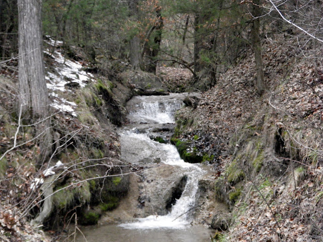
The rest of the paddle went off without a hitch. Pictures:
I had a great time and met some great, new paddling (or soon to be paddling) friends. I think everyone had a great time; I know I heard Brenda talking about buying herself a kayak. I also, remembered to give everyone a POTM sticker at the end of the trip. I would love to started seeing my stickers all over the rivers and lakes of South Dakota :)
I am sorry if I got anyone's name wrong, feel free to correct me in the comments. Also, I can't quite recall the names of the canoe and kayak paddlers that did not camp with us. I think it was a Roger, Tom, and Steve? Again, feel free to correct me in the comments.
I reached the campground and Smith Falls State Park (near Valentine, NE) first and discovered the sloppy mess of the road from the highway to the campground. Despite my many attempts, I failed to get my pickup stuck. But I was still concerned for other vehicles and just the sloppy conditions in general. I contacted Cory by text message (cell service too poor for calls) to warn him about the road and headed back to Valentine. I checked a motel for availability and rate, but decided to hold off. I met up with Cory, Matt Story, and Willard Story. They had a tougher trip than I did:

We decided to head back to the campground and give it another go. I felt better about driving on the road with another, larger 4x4 pickup. Plus, as the temperature dropped the muck froze and firmed up the road. Not too long after we started setting up camp, John Geyer and his wife Jen showed up too. We also had a few people coming down in a Toyota Prius. We were waiting for them to text Cory from the intersection of the state park road and the highway, but we were surprised to see them drive right in to our campsite. Remember, the ground is frozen at this point. Occupying the Prius were David Traxler, his wife Rebecca Traxler, and Brenda Poppens. After getting camp setup, everyone pretty much hung around the campfire BSing.

The next morning, we started gathering our gear for the first day of paddling. Once organized, we headed to Valentine for breakfast, leaving the Prius at the campground for a shuttle vehicle. After copious amounts of coffee and a delicious breakfast sandwich with hashbrowns, we headed to Cornell Bridge to launch the beginning of this paddling adventure. Keep in mind, this group is a mixture of experienced paddlers and newbies.
At the put-in, we came across three more paddlers who had contacted Cory, but left no contact information. They had a small kayak and an aluminum canoe. We took our time launching, so we could make sure everyone had appropriate gear and were comfortable with the boats they were paddling. Disaster tried to strike our hearty party early though. Rebecca spilled almost immediately after launching. Cory was standing in the water to help launch people, so he was able to quickly get her ashore to change into dry clothes.
Brenda was also launching at the time and headed downstream to try to catch the errant paddle from the spill.
Moments later, I headed downstream to assist in the retrieval of the paddle. After I passed under Cornell Bridge, I discovered that Brenda had flipped her kayak in her gallant paddle retrieval. When I arrived at the scene, she already had her gear, boat, and the errant paddle ashore. As she changed into dry clothes, I powered my way against the Niobrara current to return the paddle to Rebecca. Things were looking gloomy; two swimmers in under 10 minutes! Cory was quite concerned with out predicament. But both paddlers were prepared and were wearing clothes that would dry quickly and had packed extra dry clothes to have along. We continued on.

The rest of the day's paddling went off without a hitch. Everyone that was camping had some connection with the Boy Scouts and fulfilled the motto: Be Prepared. A slideshow of my pictures from Saturday:
After arriving back at Smith Falls State Park, those of us with vehicles at the put-in hopped into the Prius with David. This is where I learned about the exciting new option on the Toyota Prius: off-road package. This package includes 4 fat guys to push the Prius uphill through mud! After retrieving the vehicles, we all make it back to the campground without incident. We had a delicious supper of Indian tacos and cobbler for dessert.
After a good night's sleep, we were ready to conquer the next section of river. Cory drove my pickup to the take out along with the other vehicles since he knew how to get to it. The Prius brought everyone back to Smith Falls State Park. It took them a little longer than expected, because Cory's shortcut got the Prius buried, again!
 |
| Waiting for the Prius to return. |
Launching went a lot smoother today, but disaster would try to rear it's ugly head again...
 |
| Launching on Sunday morning. |

Monday, April 11, 2011
11 April 2011
I went for another La Framboise Island circumnavigation after my run this afternoon. The high temperature was 65 degrees with no wind. A perfect day for paddling.
This time I obtained results from the Endomondo app on my phone that more closely matches previous data from my gps. I am not sure what happened the last time, but it was only off about 0.1. The route should should be between 5.7 and 5.8 miles and I only trust gps accuracy (my phone or my garmin handheld) to a tenth of a mile. The first circumnavigation with the app resulted in 5.9 and tonight was 5.7 (rounded).
This time I obtained results from the Endomondo app on my phone that more closely matches previous data from my gps. I am not sure what happened the last time, but it was only off about 0.1. The route should should be between 5.7 and 5.8 miles and I only trust gps accuracy (my phone or my garmin handheld) to a tenth of a mile. The first circumnavigation with the app resulted in 5.9 and tonight was 5.7 (rounded).
 |
| From 2011-04-11 |
 |
| From 2011-04-11 |
Friday, April 8, 2011
First La Framboise Island Circumnavigation of the Year
After getting a good run in with my dog, Indy, I decided I needed to start paddling to get into shape for the South Dakota Kayak Challenge. The sun came out for the first time today as I was driving down to the causeway. I chose to complete my first circumnavigation of La Framboise Island tonight. It went well. Nothing of significance to take a picture of though. The water seemed plenty high and I had a head wind in the teens (mph) for the first half of the paddle, but it was at my back later. The air temperature was around 50 degrees. Some stats from Endomondo:
Sunday, April 3, 2011
Creek Boating
This weekend I took advantage of the open invitation from the Black Hills Paddlers to try creek boating. I joined them for a pool session on Saturday night to get accustomed to the play boat I would be borrowing for the planned paddle on Sunday. I also was borrowing a whitewater paddle, helmet, and a splash skirt for the play boat. I still don't have rolling down, but I feel that I have all the pieces, I just need to put it all together.
On Sunday morning, we met to carpool to Sand Creek near Beulah, WY. NOAA says the air temperature for Beulah was in the mid to upper 30s, plus it was quite windy. There were many little drops and a couple of substantial drops along our route. All in all, it was a great paddle. I had a great time; Thanks to Justin, Kelly, and all of the Black Hills Paddlers. I would urge all of my flat water paddling friends to contact Justin, Kelly, or any of the Black Hills Paddlers about getting a taste of whitewater and creek boating. And, of course, a few pictures from the outing.
On Sunday morning, we met to carpool to Sand Creek near Beulah, WY. NOAA says the air temperature for Beulah was in the mid to upper 30s, plus it was quite windy. There were many little drops and a couple of substantial drops along our route. All in all, it was a great paddle. I had a great time; Thanks to Justin, Kelly, and all of the Black Hills Paddlers. I would urge all of my flat water paddling friends to contact Justin, Kelly, or any of the Black Hills Paddlers about getting a taste of whitewater and creek boating. And, of course, a few pictures from the outing.
 |
| From 2011-04-03 |
 |
| From 2011-04-03 |
 |
| From 2011-04-03 |
 |
| From 2011-04-03 |
 |
| From 2011-04-03 |
Subscribe to:
Posts (Atom)