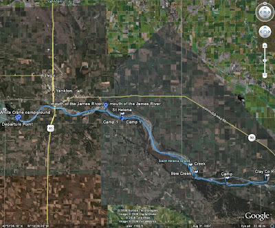
Back to the trip. The forecast was for a decent Saturday but high wind advisories and likliness of thunderstorms convinced us to use the Clay County Rec. Area as our take out. Initially, we planned to camp at Bow Creek (undeveloped National Park Service land). We shuttled my pickup downstream at 7 AM, then got the boats loaded. We launched at 10AM.
| From Missouri River - Gavins Pt to Clay Co |
| From Missouri River - Gavins Pt to Clay Co |
 |
| From Missouri River - Gavins Pt to Clay Co |
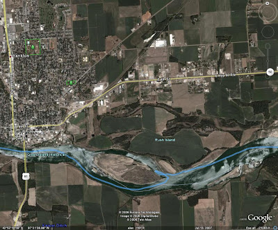
Just past Yankton, we ventured around the point of Rush Island to checkout something we saw and could not initially identify.
| From Missouri River - Gavins Pt to Clay Co |
| From Missouri River - Gavins Pt to Clay Co |
...And burned and pillaged whatever is beyond those trees ;)
With the great time we were making downstream, we decided to stop at the St Helena boat access for lunch. And not a cold lunch either! We took the time to pull out our stoves and have a hot meal. I had beef ramen (reminiscent of my college days) and John had flavored rice.
| From Missouri River - Gavins Pt to Clay Co |
| From Missouri River - Gavins Pt to Clay Co |
| From Missouri River - Gavins Pt to Clay Co |
| From Missouri River - Gavins Pt to Clay Co |
On the upstream end of Goat Island, we beached our boats and explored a bit. The location was not great for setting up camp, but we were surprised to find a pickup camper mounted to a small trailer in amongst a somewhat heavily wooded area. Due to it's condition, it had been there awhile.
We continued along Goat Island until we found a suitable camp location. Our aerial photos helped significantly in this regard.
| From Missouri River - Gavins Pt to Clay Co |
| From Missouri River - Gavins Pt to Clay Co |
For supper, I had Dinty Moore Beef Stew and John had some Campbell's Chunky Soup among other things. I think we both slept well that night and were both up before sunrise. I had oatmeal for breakfast and John had a Mountain Dew. We were back on the water at sunrise.
We were on the water for less than an hour before coming to the Clay County Rec. Area. We put 4 miles that morning, giving us a total of 28.7 for the trip.
 |
| From Missouri River - Gavins Pt to Clay Co |
A slide show of all of my pictures:
The short day on Sunday actually gave me time to visit my sister in Vermillion, catch my Panthers get smoked by the Bucs at Champs in SF, and get home before too late. What this trip did though is pump me up to do more like trips. For example:
- Gavins Point to Ponca State Park
- Fort Randall to Running Wate
- Hwy 34 to Hwy 63 (Cheyenne River) I did this one by canoe when I was in Jr High.
- Possibly a section of the Minnesota River
- Water Trails in MN
An excellent idea would be to have a SDCA cruise from Gavins Point to Ponca State Park. Anyone wanting to just paddle a portion of it could find another take out easily.
ADDED: A slideshow of the pictures John Adler took.

What a GREAT trip. After correcting for some errors in my GPS, I got it to show a total trip length of 28.8 miles. When you consider that we got a later start on Saturday and got done early on Sunday (good thing we did since the weather continued to get worse throughout the day), we took under 23 hours to complete it.
ReplyDeleteThe rain made for an interesting trip. But, that is just part of what can happen.
I think we both learned a lot and can, hopefully, take what we learn and make some more trips next year.
Thanks for sharing your trip, Pat. It was a great vicarious cruise for me, and it made me wish that I had dropped everything and joined in. I thought that the description of passing under the Yankton bridge and heading down to Goat Island was especially attractive. I like your notion of overnight SDCA sponsored cruises on the Missouri, and I hope that it comes to pass next season.
ReplyDelete